Bar Swat District lit. 'Upper Swat District' is a newly created district in Khyber Pakhtunkhwa, Pakistan. It was carved out of the Swat District in October 2025.[3] It consists of the Behrain, Matta and Khwazakhela Tehsils of former Swat District, with Matta as headquarters.[4][5]
With lush forests, verdant alpine meadows, and snow-capped mountains, Upper Swat is one of the country's most popular tourist destinations.[6][7]
Geography

Upper Swat District is centered around Swat Kohistan. Swat Kohistan forms the larger, northern part of the district, and is mainly inhabited by the indigenous Kohistani, Torwali and Kalami peoples. The lower parts forms the lower portion of the district and has a Pashtun majority, with a significant Gujar population.[5] In terms of administrative divisions, Swat is surrounded by Lower Chitral and Upper Dir to the west, Gilgit-Baltistan to the north, and Kohistan and Shangla to the east and southeast, respectively.
The Swat Valley is enclosed by mountains that forms a natural geographic boundary for it. The Swat River whose headwaters arise in the 5,500-to-5,800-metre-tall (18,000–19,000 ft) Hindu Kush mountain range runs through the length of the region. The main area consists of many sub valleys such as Kalam, Bahrain, Matiltan, Utror, and Gabral.
History
In August 2025, the Khyber Pakhtunkhwa government announced the plan to divide the Swat district. A notification was issued by the Revenue Department directing the Commissioners of Malakand Division and the Deputy Commissioner of Swat to submit a report on the division plan within three days.[8][9]
On 19 December the provincial cabinet approved the bifurcation of the district and the creation of Upper Swat District, with Matta as the headquarters.[4]
Demographics
Languages
Upper Swat District is mostly inhabited by Pashto speaking communities who make up 83.27% of the population.[10] Languages classified as 'Others', mainly Gawri and Torwali, are spoken by 13.48% of the population, and form the majority in the Swat Kohistan region of Upper Swat.[10]
Administrative divisions

Upper Swat is subdivided into three administrative units, known as Tehsils:
| Tehsil | Area
(km2)[11] |
Pop.
(2023) |
Density
(ppl/km2) (2023) |
Literacy rate
(2023)[12] |
Union Councils |
|---|---|---|---|---|---|
| Behrain Tehsil | 2,899 | 270,623 | 93.35 | 39.26% | |
| Matta Tehsil | 684 | 552,431 | 807.65 | 42.54% | |
| Khwaza Khela Tehsil | 392 | 307,300 | 783.93 | 42.63% |
Each tehsil comprises certain numbers of union councils.
Gallery
-
 Falak Sar, Swat's tallest mountain at 5,957 metres (19,544 ft)
 -
 Mankial Sar, which rises to 5,700 m (18,600 ft)
 -
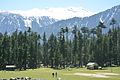 Pine forests occur in Swat at elevations over 1,500 m (5,000 ft)
 -
 The northernmost region of Swat – a region known as Kohistan – has high alpine valley at the base of tall mountains
 -
 Jarogo Waterfall, in middle Swat
 -
 Alpine lakes, such as Mahodand Lake are found in the mountains of Swat Kohistan.
 -
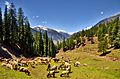 Alpine meadows in Utror


References
- ^ Malala Yousafzai (8 October 2013). I Am Malala: The Girl Who Stood Up for Education and Was Shot by the Taliban. Little, Brown. p. 16. ISBN 978-0-316-32241-6.
The Taliban destroyed the Buddhist statues and stupas where we played Kushan kings haram Jehanabad Buddha.
- ^ "Literacy rate, enrolments, and out-of-school population by sex and rural/urban, CENSUS-2023, KPK" (PDF).
- ^ "KP Cabinet approves measures to cement governance, improve service delivery, ensure public welfare". Pakistan Today. 3 October 2025.
- ^ a b "KP cabinet approves Ehsaas Rehribaan law, new Upper Swat district". Associated Press of Pakistan. 19 December 2025. Retrieved 19 December 2025.
- ^ a b Torwali, Zubair (5 September 2025). "Let there be more districts?". The News International. Retrieved 10 October 2025.
- ^ Khaliq, Fazal (17 January 2018). "Tourists throng Swat to explore its natural beauty". DAWN.COM. Archived from the original on 11 February 2018. Retrieved 10 February 2018.
- ^ "The revival of tourism in Pakistan". Daily Times. 9 February 2018. Archived from the original on 13 February 2018. Retrieved 12 February 2018.
- ^ "KP govt to split Swat into two districts". GNN HD. 29 August 2025.
- ^ "Khyber Pakhtunkhwa govt to split Swat into two districts". Daily Times. 29 August 2025.
- ^ a b c "7th Population and Housing Census - Detailed Results: Table 11" (PDF). Pakistan Bureau of Statistics. Archived (PDF) from the original on 19 August 2024. Retrieved 2 August 2024.
- ^ Khaliq, Fazal (17 January 2018). "Tourists throng Swat to explore its natural beauty". DAWN.COM. Archived from the original on 11 February 2018. Retrieved 10 February 2018.
- ^ "The revival of tourism in Pakistan". Daily Times. 9 February 2018. Archived from the original on 13 February 2018. Retrieved 12 February 2018.

Administrative divisions of Upper Swat District | ||
|---|---|---|
| Capital | ||
| Tehsils | ||
| Union councils | ||