The U.S. Roads Portal
The highway system of the United States is a network of interconnected state, U.S., and Interstate highways. Each of the fifty states, the District of Columbia, Puerto Rico, American Samoa, Guam, the Northern Mariana Islands, and the U.S. Virgin Islands own and maintain a part of this vast system, including U.S. and Interstate highways, which are not owned or maintained at the federal level.


Interstate Highways have the highest speed limits and the highest traffic numbers. Interstates are numbered in a grid: even-numbered routes for east–west routes (with the lowest numbers along Mexico and the Gulf of Mexico), and odd-numbered routes are north–south routes (with the lowest numbers along the Pacific Ocean). Three-digit Interstates are, generally, either beltways or spurs of their parent Interstates (for example, Interstate 510 is a spur into the city of New Orleans, Louisiana, and is connected to Interstate 10).


U.S. Numbered Highways are the original interstate highways, dating back to 1926. U.S. Highways are also numbered in a grid: even numbered for east–west routes (with the lowest numbers along Canada) and odd numbered for north–south routes (with the lowest numbers along the Atlantic Ocean). Three-digit highways, also known as "child routes," are branches off their main one- or two-digit "parents" (for example, U.S. Route 202 is a branch of U.S. Route 2). However, US 101, rather than a "child" of US 1, is considered a "mainline" U.S. Route.


State highways are the next level in the hierarchy. Each state and territory has its own system for numbering highways, some more systematic than others. Each state also has its own design for its highway markers; the number in a circle is the default sign, but many choose a different design connected to the state, such as an outline of the state with the number inside. Many states also operate a system of county highways.


Scenic byways can be designated over any classification of road in the United States. There are the National Scenic Byways, National Forest Scenic Byways and Bureau of Land Management Back Country Byways at the national level. Most states have their own system for designating byways, some more systematic than others. Native American tribes may designate byways as well.
 Featured articles -

-


Interchange with I-55 in Bolingbrook, formerly the southern terminus of I-355
Interstate 355 (I-355), also known as the Veterans Memorial Tollway, is an Interstate Highway and tollway in the western and southwest suburbs of Chicago in the U.S. state of Illinois. Like most other toll roads in the northeastern portion of the state, I-355 is maintained by the Illinois State Toll Highway Authority (ISTHA). I-355 runs from I-80 in New Lenox north to I-290 in Itasca, a distance of 32.5 miles (52.3 km). With the exception of a four-mile (6.4 km) expansion in 2009, from U.S. Route 34 (US 34, Ogden Avenue) to 75th Street, the highway is six lanes wide for its entire length.
The tollway authority opened I-355 as the North–South Tollway in 1989 to ease congestion on Illinois Route 53 (IL 53), a parallel two-lane state highway in central DuPage County. Initially, I-355 ran from I-55 north to I-290. The new highway helped cut travel times for commuters traveling north and south in the county. According to commercial real estate developers at the time, the new tollway also opened the western suburbs of Chicago to commercial and industrial development. (Full article...) -
Interstate 94 (I-94) is a part of the Interstate Highway System that runs from Billings, Montana, to the Lower Peninsula of the US state of Michigan. In Michigan, it is a state trunkline highway that enters the state south of New Buffalo and runs eastward through several metropolitan areas in the southern section of the state. The highway serves Benton Harbor–St. Joseph near Lake Michigan before turning inland toward Kalamazoo and Battle Creek on the west side of the peninsula. Heading farther east, I-94 passes through rural areas in the middle of the southern Lower Peninsula, crossing I-69 in the process. I-94 then runs through Jackson, Ann Arbor, and portions of Metro Detroit, connecting Michigan's largest city to its main airport. Past the east side of Detroit, the Interstate angles northeasterly through farmlands in The Thumb to Port Huron, where the designation terminates on the Blue Water Bridge at the Canada–United States border.
The first segment of what later became I-94 within the state, the Willow Run Expressway, was built near Ypsilanti and Belleville in 1941, with an easterly extension to Detroit in 1945. This expressway was initially numbered M-112. In the mid-1950s, state and federal officials planned an Interstate to replace the original route of US Highway 12 (US 12). By 1960, the length of I-94 was completed from Detroit to New Buffalo. Two years later, the US 12 designation was dropped from the freeway. Subsequent extensions in the 1960s completed most of the rest of the route, including the remaining sections between Detroit and Port Huron which superseded the routing of US 25. The last segment opened to the public in 1972 when Indiana completed its connection across the state line. Since completion, I-94 has remained relatively unchanged; a few interchanges have been rebuilt, a second span was constructed for the Blue Water Bridge, and, in 1987, a plane crashed on the freeway during takeoff from the airport in Detroit. The routing of I-94 is notable for containing the first full freeway-to-freeway interchange in the United States, connecting to the Lodge Freeway (M-10), and for comprising the first complete border-to-border toll-free freeway in a state in the United States. The highway has one auxiliary route, I-194, which serves downtown Battle Creek, and eight business routes. Various segments have been dedicated to multiple people and places. (Full article...) -
US Highway 45 (US 45) is a part of the United States Numbered Highway System that runs from Mobile, Alabama, to the Upper Peninsula (UP) of the state of Michigan. The highway forms a part of the state trunkline highway system that is maintained by the Michigan Department of Transportation (MDOT). It enters the state from Wisconsin south of Watersmeet, ending at an intersection with Ontonagon Street in Ontonagon. In between, the roadway crosses the UP running for approximately 54+3⁄4 miles (88.1 km) through the Ottawa National Forest and parallel to the Ontonagon River.
The highway dates back to the 1930s in Michigan. At the time it was extended into the state, it replaced sections of M-26 and M-35. An eight-mile (13 km) segment was significantly reconstructed in the late 1950s, and an alignment change in the 1970s moved the routing of US 45 near Rockland before it was reversed soon afterwards. A segment of roadway that formerly carried US 45 is the site of the Paulding Light, a local phenomenon whose origins were scientifically described in 2010. (Full article...) -
New York State Route 308 (NY 308) is a short state highway, 6.19 miles (9.96 km) in length, located entirely in northern Dutchess County, in the U.S. state of New York. It is a major collector road through a mostly rural area, serving primarily as a shortcut for traffic from the two main north–south routes in the area, U.S. Route 9 (US 9) and NY 9G, to get to NY 199 and the Taconic State Parkway. The western end of NY 308 is located within Rhinebeck's historic district, a 2.6-square-mile (6.7 km2) historic district comprising 272 historical structures. The highway passes near the Dutchess County Fairgrounds, several historical landmarks, and briefly parallels the Landsman Kill.
Artifacts found near Lake Sepasco, near NY 308's eastern terminus at Rock City, date to about 1685, when the Sepasco Native Americans built the Sepasco Trail from the Hudson River, eastward through modern-day Rhinebeck (then Sepasco or Sepascoot) to the lake, following roughly NY 308 and its side roads. The trail remained until 1802, when part of the Ulster and Delaware Turnpike—also known as the Salisbury Turnpike—was chartered over the trail and extended from Salisbury, Connecticut, to the Susquehanna River at or near the Town of Jericho (now Bainbridge). (Full article...) -
Interstate 182 (I-182) is an east–west auxiliary Interstate Highway in the U.S. state of Washington. It connects I-82 to the Tri-Cities region and crosses the Columbia River on the Interstate 182 Bridge between Richland and Pasco. I-182 is 15 miles (24 km) long and entirely concurrent with U.S. Route 12 (US 12). It also intersects Washington State Route 240 (SR 240) and US 395.
Business leaders in the Tri-Cities began lobbying for a freeway in 1958 after early alignments for I-82 were routed away from the area. I-182 was created by the federal government in 1969 as a compromise that would directly connect to the Tri-Cities area while allowing other traffic to bypass it. The project would also incorporate an existing proposal to build a bridge between Richland and Pasco at the site of a cable ferry that ran until 1931. (Full article...) -
Interstate 75 (I-75) is a part of the Interstate Highway System that runs from the Hialeah–Miami Lakes line to the Canadian border at Sault Ste. Marie, Michigan. I-75 enters the state from Ohio in the south, north of Toledo, and runs generally northward through Detroit, Flint, and Bay City, crosses the Mackinac Bridge and ends at the border in Sault Ste. Marie. The freeway runs for approximately 396 miles (637 km) on both of Michigan's major peninsulas. The landscapes traversed by I-75 include Southern Michigan farmland, northern forests, suburban bedroom communities, and the urban core of Detroit. The freeway also uses three of the state's monumental bridges to cross major bodies of water. There are four auxiliary Interstates in the state related to I-75, as well as nine current or former business routes, with either Business Loop I-75 (BL I-75) or Business Spur I-75 (BS I-75) designations.
The freeway bears several names in addition to the I-75 designation. The southern segment was called the Detroit–Toledo Expressway during planning in the 1950s and 1960s. Through Detroit, I-75 is the Fisher Freeway or the Walter P. Chrysler Freeway, named for pioneers in the auto industry. Sections on either side of the Mackinac Bridge are the G. Mennen Williams Freeway or the Prentiss M. Brown Freeway, named for politicians who helped get the bridge built. Officially, the entire length is the American Legion Memorial Highway, after the organization of the same name. Various sections carry components of the four Great Lakes Circle Tours in the state. (Full article...) -
U.S. Route 50 (US 50) is a transcontinental highway in the United States, stretching from West Sacramento, California, in the west to Ocean City, Maryland, on the east coast. The Nevada portion crosses the center of the state and was named "The Loneliest Road in America" by Life magazine in July 1986. The name was intended as a pejorative, but Nevada officials seized it as a marketing slogan. The name originates from large desolate areas traversed by the route, with few or no signs of civilization. The highway crosses several large desert valleys separated by numerous mountain ranges towering over the valley floors, in what is known as the Basin and Range province of the Great Basin.
US 50 has a diverse route through the state, traversing the resort communities of Lake Tahoe, the state capital in Carson City, historical sites such as Fort Churchill State Historic Park, petroglyphs, alpine forests, desert valleys, ghost towns, and Great Basin National Park. (Full article...) -

Brockway Mountain Drive is an 8.8-mile-long (14.2 km) scenic roadway just west of Copper Harbor in the Upper Peninsula of Michigan in the United States. Drivers can access the road from State Highway M-26 on either end near Eagle Harbor to the west or Copper Harbor to the east in the Keweenaw Peninsula. The drive runs along the ridge of Brockway Mountain on the Keweenaw Fault and climbs to 1,320 feet (402 m) above sea level, 720 feet (219 m) above the surface of Lake Superior. Several viewpoints along the route allow for panoramas of Copper Harbor, Lake Superior, and undeveloped woodland. On a clear day, Isle Royale is visible approximately 50 miles (80 km) in distance from the top of the mountain.
Brockway Mountain was named for Daniel D. Brockway, one of the pioneer residents of the area. The road was constructed by the county road commission with funding through Depression-era work programs in 1933. It was briefly used as a connection for the parallel state highway after it opened. Since it opened, Brockway Mountain Drive has been recognized nationally and locally in several media outlets for its picturesque qualities, usually in profiles of Keweenaw County, the Upper Peninsula or other scenic drives. (Full article...) -
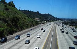
I-8 in San Diego, from the San Diego Trolley
Interstate 8 (I-8) is an Interstate Highway in the southwestern United States. It runs from the southern edge of Mission Bay at Sunset Cliffs Boulevard in San Diego, California, almost at the Pacific Ocean, to the junction with I-10, just southeast of Casa Grande, Arizona. In California, the freeway travels through the San Diego metropolitan area as the Ocean Beach Freeway and the Mission Valley Freeway before traversing the Cuyamaca Mountains and providing access through the Imperial Valley, including the city of El Centro. Crossing the Colorado River into Arizona, I-8 continues through the city of Yuma across the Sonoran Desert to Casa Grande, in between the cities of Phoenix and Tucson.
The first route over the Cuyamaca Mountains was dedicated in 1912, and a plank road served as the first road across the Imperial Valley to Yuma; east of there, the Gila Trail continued east to Gila Bend. These were later replaced by U.S. Route 80 (US 80) across California and part of Arizona, and Arizona State Route 84 (SR 84) between Gila Bend and Casa Grande. The US 80 freeway through San Diego was largely complete by the time it was renumbered as I-8 in the 1964 state highway renumbering; east of San Diego, the US 80 roadway was slowly replaced by I-8 as construction progressed in the Imperial Valley. The Arizona portion of the road was built starting in the 1960s. Several controversies erupted during the construction process; questionable labor practices in Imperial County led to the federal conviction of mobster Jimmy Fratianno, and a U.S. House of Representatives subcommittee found that the Arizona government had mismanaged financial resources. (Full article...) -
Interstate 696 (I-696) is an east–west auxiliary Interstate Highway in the Metro Detroit region of the US state of Michigan. The state trunkline highway is also known as the Walter P. Reuther Freeway, named for the prominent auto industry union head by the Michigan Legislature in 1971. I-696 is a bypass route, detouring around the city of Detroit through the city's northern suburbs in Oakland and Macomb counties. It starts by branching off I-96 and I-275 at its western terminus in Farmington Hills, and runs through suburbs including Southfield, Royal Oak and Warren before merging into I-94 at St. Clair Shores on the east end. It has eight lanes for most of its length and is approximately 10 miles (16 km) north of downtown Detroit. I-696 connects to other freeways such as I-75 (Chrysler Freeway) and M-10 (Lodge Freeway). Local residents sometimes refer to I-696 as "The Autobahn of Detroit".
Planning for the freeway started in the 1950s. Michigan state officials proposed the designation I-98, but this was not approved. Construction started on the first segment in 1961, and the Lodge Freeway was designated Business Spur Interstate 696 (BS I-696) the following year. The western third of the freeway opened in 1963, and the eastern third was completed in January 1979. The central segment was the subject of much controversy during the 1960s and 1970s. Various municipalities along this stretch argued over the routing of the freeway such that the governor locked several officials into a room overnight until they would agree to a routing. Later, various groups used federal environmental regulations to force changes to the freeway. The Orthodox Jewish community in Oak Park was concerned about pedestrian access across the freeway; I-696 was built with a set of parks on overpasses to accommodate their needs. The Detroit Zoo and the City of Detroit also fought components of the freeway design. These concessions delayed the completion of I-696 until December 15, 1989. Since completion, the speed limit was raised from 55 to 70 miles per hour (89 to 113 km/h). In addition, some interchanges were reconfigured in 2006. (Full article...) -
Interstate 296 (I-296) is a part of the Interstate Highway System in the US state of Michigan. It is a north–south state trunkline highway that runs for 3.43 miles (5.52 km) entirely within the Grand Rapids area. Its termini are I-196 near downtown Grand Rapids and I-96 on the north side of Grand Rapids in Walker. For most of its length, the Interstate runs concurrently with U.S. Highway 131 (US 131), which continues as a freeway built to Interstate Highway standards north and south of the shorter I-296. The highway was first proposed in the late 1950s and opened in December 1962, but the Michigan Department of Transportation (MDOT) has since eliminated all signage for I-296 and removed the designation from their official state map. The designation is therefore unsigned, but still listed on the Interstate Highway System route log maintained by the Federal Highway Administration (FHWA). (Full article...)
-
US Highway 31 (US 31) is a part of the United States Numbered Highway System that runs from Alabama to the Lower Peninsula of the US state of Michigan. In Michigan, it is a state trunkline highway that runs along the western portion of the Lower Peninsula, from the Indiana–Michigan state line at Bertrand Township north to its terminus at Interstate 75 (I-75) south of Mackinaw City. Along its 355.2-mile-long (571.6 km) route, US 31 follows the Michigan section of the St. Joseph Valley Parkway as well as other freeways and divided highways northward to Ludington. North of there, the trunkline is a rural undivided highway through the Northern Michigan tourist destinations of Traverse City and Petoskey before terminating south of Mackinaw City. Along its route, US 31 has been dedicated in memory of a few different organizations, and sections of it carry the Lake Michigan Circle Tour (LMCT) moniker. Four bridges used by the highway have been recognized for their historic character as well.
The first highways along the route of the modern US 31 corridor were the West Michigan Pike, an auto trail from 1913, and later a pair of state trunklines (the original M-11 and M-58) in 1919. These state highways were redesignated US 31 on November 11, 1926, when the US Highway System was approved. Since then, the highway has been realigned in places. The highway crossed the Straits of Mackinac by ferry for about a decade in the 1920s and 1930s before the Mackinac Bridge was built, connecting to US 2 north of St. Ignace. Later, sections were converted into freeways starting in the 1950s. These segments opened through the subsequent decades with the last one opening in 2022. Future plans by the Michigan Department of Transportation (MDOT) include a bypass of Grand Haven. (Full article...) -
H-58 is a county-designated highway in the US state of Michigan that runs east–west for approximately 69 miles (111 km) between the communities of Munising and Deer Park in the Upper Peninsula. The western section is routed through Pictured Rocks National Lakeshore, along the southern shore of Lake Superior, and the adjacent Lake Superior State Forest in Alger County while connecting Munising to the communities of Van Meer and Melstrand. At Grand Marais, H-58 exits the national lakeshore area and runs through town. The segment running east of Grand Marais to Deer Park in Luce County is a gravel road that connects to H-37 in Muskallonge Lake State Park.
A roadway was present along parts of today's H-58 by the late 1920s; initially, this county road was gravel or earth between Munising and Kingston Corners and connected with other roads to Grand Marais. In the 1930s, another segment was built to connect to Deer Park and to fill in the gap between Kingston Corners and Grand Marais. The southwestern segment between Munising and Van Meer formed part of M-94 from 1929 until it was transferred back to county control in the early 1960s. (Full article...) -
The Chickasaw Turnpike, also designated State Highway 301 (SH-301), is a controlled-access road in the rural south central region of the U.S. state of Oklahoma. A two-lane freeway, it stretches for 13.3 miles (21.4 km) from north of Sulphur to just south of Ada. The Oklahoma Turnpike Authority (OTA) owns, maintains, and collects tolls on the turnpike. The first section of the Chickasaw Turnpike opened on September 1, 1991.
The Chickasaw resulted from a compromise between urban and rural legislators. Originally, it was part of a now-canceled plan to connect southern and eastern Oklahoma with a longer turnpike. It was also intended to link Ada to the Interstate system. A four-mile (6.4 km) segment of the turnpike was transferred to the Oklahoma Department of Transportation (ODOT), making it a toll-free road, in 2011. (Full article...) -
Interstate 68 (I-68) is a 113.15-mile (182.10 km) Interstate Highway in the U.S. states of West Virginia and Maryland, connecting I-79 in Morgantown, West Virginia, east to I-70 in Hancock, Maryland. I-68 is also Corridor E of the Appalachian Development Highway System (ADHS). From 1965 until the freeway's construction was completed in 1991, it was designated as U.S. Route 48 (US 48). In Maryland, the highway is known as the National Freeway, an homage to the historic National Road, which I-68 parallels between Keysers Ridge and Hancock. The freeway mainly spans rural areas and crosses numerous mountain ridges along its route. A road cut at Sideling Hill exposed geological features of the mountain and has become a tourist attraction.
US 219 and US 220 overlap I-68 in Garrett County and Cumberland, respectively, and US 40 overlaps with the freeway from Keysers Ridge to the eastern end of the freeway at Hancock. (Full article...)


 Good articles -

-
New York State Route 812 (NY 812) is a state highway in the North Country of New York in the United States. The southern terminus of the route is at an intersection with NY 12 and NY 26 in the Lewis County village of Lowville. Its northern terminus is at the Canada–United States border in Ogdensburg, where it crosses the Ogdensburg–Prescott International Bridge and connects to Highway 16 in Ontario. While most of NY 812 passes through rural areas of the North Country, the route also serves several villages and small communities. The GPS services company Geotab has named it the quietest highway in New York due to its low traffic counts.
The origins of NY 812 date back to the 1930 renumbering of state highways in New York, when the portion of modern NY 812 from Lowville to Croghan became part of NY 26A and the segment of modern NY 812 between De Kalb and Ogdensburg was designated as the northernmost portion of New York State Route 87. NY 87 originally extended as far south as Harrisville; however, it was truncated north to Edwards in the 1940s and farther north to De Kalb in the 1970s. (Full article...) -
State Highway 112 (SH 112) is a 27.802-mile-long (44.743 km) state highway in southern Colorado. Built in 1916 and formally defined in 1922, the route begins at its western end in Del Norte at a junction with U.S. Highway 160 (US 160). From there the road travels east crossing US 285 two miles (3.2 km) west of Center before reaching its eastern terminus at Hooper where it meets SH 17. (Full article...)
-
State Route 113 (SR 113), also known as Burnt Mountain Road, is a Washington state highway in Clallam County on the Olympic Peninsula. It connects U.S. Route 101 (US 101) at Sappho to SR 112 near Clallam Bay, traveling north along Beaver Creek and the Pysht River for 10 miles (16 km).
The highway follows a wagon road constructed in 1892 and maintained by the county government until it was transferred to the state highway system in 1937. It was part of Secondary State Highway 9A (SSH 9A), which connected Sappho to Port Angeles along the Strait of Juan de Fuca. The north–south section of SSH 9A was removed from the state highway system in 1955 and was transferred back to Clallam County and renamed Burnt Mountain Road. (Full article...) -
M-49 is a north–south state trunkline highway in the south-central portion of the US state of Michigan. It runs from the Ohio state line north to Litchfield through rural Hillsdale County. M-49 is the only Michigan highway in which the road crossing into another state has the same state highway number. M-49 continues as State Route 49 (SR 49), near the Indiana–Michigan–Ohio tripoint south of Camden. The highway dates back to 1930 and was only altered once in the 1940s. M-49 runs through Southern Michigan farmlands connecting several small towns along its path. At one point, M-49 briefly runs concurrently with US Highway 12 (US 12). (Full article...)
-
US Route 223 or US Highway 223 (US 223) is a diagonal (northwest–southeast) United States Numbered Highway lying in the states of Michigan and Ohio. The southernmost section is completely concurrent with the US 23 freeway, including all of the Ohio segment. It connects US 23 in the south near Toledo, Ohio, with US 127 south of Jackson, Michigan. The highway passes through farmland in southern Michigan and woodland in the Irish Hills. Including the concurrency on the southern end, US 223 is 46.34 miles (74.58 km) in total length.
The highway designation was created in 1930 out of the southern end of US 127. Three sets of reroutings through Adrian have resulted in the creation of two different business loops through the city. A change proposed in the 1960s and implemented in the 1970s shifted the southern end of US 223 to replace M-151 and then run along the US 23 freeway between Whiteford Township, Michigan, and Sylvania, Ohio. Since the 1980s, US 223 no longer reaches Toledo, instead feeding into the freeway system for the city. Changes proposed and enacted into law in the 1990s would upgrade the highway as an Interstate Highway. Congress has designated this corridor as part of Interstate 73 (I-73), although neither state intends to complete the freeway at this time. (Full article...) -

State Route 174 (SR 174) is a 40.66-mile (65.44 km) long state highway that traverses Douglas, Grant and Lincoln counties in Washington. SR 174 begins at a junction with SR 17 in Leahy and travels eastward to Grand Coulee, near the Grand Coulee Dam, to intersect SR 155. From Grand Coulee, the roadway travels southeast to end at SR 21 northwest of Wilbur.
Prior to the establishment of SR 174 in a 1964 renumbering, it had been county roads and two highways, Secondary State Highway 10B (SSH 10B) and Secondary State Highway 4C (SSH 4C) from 1937 until 1964. The two highways merged to form SR 174 in 1964 and a branch of SSH 10B became the Crown Point spur of SR 174. A second spur route, located in Leahy, was added in 2009. (Full article...) -

The western end of I-205, as seen by eastbound traffic entering from I-580
Interstate 205 (I-205) is an east–west auxiliary Interstate Highway in the San Joaquin Valley in Northern California. It runs from I-5 west to I-580. Along with those highways, I-205 forms the north side of a triangle around the city of Tracy. The route provides access from the San Francisco Bay Area to the northern San Joaquin Valley.
When I-205 opened in December 1970, it replaced 11th Street, which passed through downtown Tracy, as part of the primary all-land connection between the Bay Area and Sacramento until the Carquinez Bridge opened in 1927 and carried the Lincoln Highway and later US Route 50 (US 50). 11th Street is now signed as I-205 Business (I-205 Bus.). (Full article...) -
New York State Route 96 (NY 96) is a 126.01-mile-long (202.79 km) northwest–southeast state highway in the Finger Lakes region of New York in the United States. The southern terminus of the route is at an interchange with I-86 in the Southern Tier village of Owego, Tioga County. Its northern terminus is at a junction with East Main Street in the city of Rochester, Monroe County. Between the two endpoints, NY 96 passes through the city of Ithaca and the villages of Waterloo, Victor, and Pittsford. NY 96 is signed north–south for its entire length, although most of the route in Ontario County travels in an east–west direction.
All of NY 96, except from Candor to Ithaca and from northwest of Victor to Pittsford, was originally designated as part of New York State Route 15 in 1924. NY 15 was originally routed on modern NY 96B between Candor and Ithaca, and modern NY 64 and NY 251 between Victor and Pittsford. It was realigned onto the modern alignment of NY 96 between Victor and Pittsford in 1930. NY 15 was renumbered to New York State Route 2 c. 1939 to eliminate duplication with U.S. Route 15 (US 15). NY 2 was subsequently redesignated as NY 96 in 1942 as the alignments of NY 2 and NY 96, a route in Rensselaer County, were swapped. NY 96 was realigned again in the early 1950s, this time between Candor and Ithaca, to serve the village of Spencer west of Candor. Near Rochester, NY 96 followed what is now Interstate 490 (I-490) for a short time during the 1950s and early 1960s. The 2017 route log erroneously shows that NY 96's northern terminus ends at Union Street. Whether by accident or as a prank, there is occasionally a route sign that was installed upside down. You can notice this when you see the white shield that surrounds the "96" with its point on the top. (Full article...) -
New York State Route 171 (NY 171) is a state highway running east to west through Herkimer County, New York, in the United States. It connects the hamlet of Gulph in the town of Frankfort to the village of Frankfort by way of the Frankfort Gorge. Its western end is at the junction of County Route 145 (CR 145) and CR 185 southeast of Gulph. The eastern end is 5.69 miles (9.16 km) to the east at an intersection with Main Street in Frankfort village. NY 171 is a narrow, two-lane highway for its whole length.
NY 171 is the only signed state highway in New York that does not intersect any other signed New York state routes. However, this was not always the case. When it was originally assigned as part of the 1930 renumbering of state highways in New York, Main Street in Frankfort was part of NY 5S. A new freeway alignment for NY 5S was constructed between Utica and Ilion in the late 1960s, isolating NY 171 from the remainder of the state highway system. Frankfort's interchange with NY 5S is now at Cemetery Street, 0.75 miles (1.21 km) to the west. (Full article...) -
Mississippi Highway 37 (MS 37) is a state highway in central Mississippi. The route starts at U.S. Route 84 (US 84) near Collins. The road travels northward through the town of Taylorsville, crossing from Covington County to Smith County. MS 37 turns northwestward and ends at MS 35 in Raleigh. The road first existed as part of MS 35, and it became a spur route of MS 35 by 1941. It was renumbered as MS 37 by 1950, and fully paved by 1952. (Full article...)
-
Interstate 140 (I-140) and North Carolina Highway 140 (NC 140) is a 25.4-mile (40.9 km) auxiliary Interstate Highway and state highway in the U.S. state of North Carolina. Officially designated the John Jay Burney Jr. Freeway, it serves as a bypass of Wilmington. The western terminus of the highway is at U.S. Route 17 (US 17) near Winnabow. It heads north in western Leland before turning to the east north of an interchange with U.S. Route 74 (US 74)/U.S. Route 76 (US 76). I-140 crosses the Cape Fear River north of Navassa and the Northeast Cape Fear River northwest of Wrightsboro. I-140 ends at Interstate 40 (I-40), and the route number changes to NC 140. NC 140 continues to the east, ending at US 17 in Kirkland.
The need for a bypass north of Wilmington was identified by the North Carolina Department of Transportation (NCDOT) in 1972. However, the first contract for construction was not awarded until 2000. In August 2005, the first segment of I-140 between I-40 and North Carolina Highway 133 (NC 133) opened. This was followed by a westward extension to U.S. Route 421 (US 421) and an eastward extension to US 17 in June 2006. US 17 was routed along the entirety of the freeway between Kirkland and US 421, running concurrently with I-140. Construction on the western segment between Winnabow and US 74/US 76 began in March 2010 and was opened in September 2014. This segment was temporarily designated as NC 140 as it lacked connection with I-140 to the east. The final segment between US 74/US 76 and US 421 began construction in 2014 and was completed in 2017. I-140 was routed along the entirety of the freeway west of I-40. Additionally, US 17 was removed from its concurrency with I-140, being rerouted through Wilmington in 2017. The remaining section between I-40 and Kirkland was subsequently renumbered as NC 140. (Full article...) -
New York State Route 164 (NY 164) is a short state highway located entirely in the town of Patterson in northeastern Putnam County, New York, in the United States. It is a short, two-lane back road that does not pass through any major populated areas and serves primarily as a connector between NY 311 and NY 22. NY 164 also allows for faster passage from Interstate 84 (I-84) to the Putnam Lake area via NY 311. The route was originally designated as NY 312 during the 1930s and later became part of NY 216. NY 164 was established on January 1, 1970, following the truncation of NY 216 to its current eastern terminus. (Full article...)
-
Pennsylvania Route 183 (PA 183) is a 31.7-mile-long (51.0 km) route that runs north to south in southeastern Pennsylvania. The southern terminus is at U.S. Route 422 Business (US 422 Bus.) in Reading in Berks County. Its northern terminus is at PA 61 near Schuylkill Haven in Schuylkill County. The road passes through developed areas near Reading before continuing north through rural areas, crossing from Berks County into Schuylkill County at Blue Mountain. PA 183 serves the communities of Bernville, Strausstown, and Cressona.
Much of what is now PA 183 was originally designated as part of Pennsylvania Route 83 (PA 83) in 1927, a route that ran from US 30/PA 1 in Devon northwest to US 120/PA 42 (now PA 61) near Schuylkill Haven. PA 83 was realigned to a more direct route in northern Berks County by 1960, bypassing a jog to the west through Rehrersburg. In 1961, PA 83 was renumbered to PA 183 to avoid duplication with Interstate 83 (I-83) and the southern terminus was cut back to PA 23 near Phoenixville. The southern terminus was truncated to its current location in Reading by 1966. The former alignment between Devon and Reading became a part of other state routes, with some portions becoming unnumbered. (Full article...) -
U.S. Route 30 (US 30) is a part of the United States Numbered Highway System that runs from Astoria, Oregon, to Atlantic City, New Jersey. In Indiana, the route runs from the Illinois state line at Dyer to the Ohio state line east of Fort Wayne and New Haven. The 156.217 miles (251.407 km) of US 30 that lie within Indiana serve as a major conduit. The entire length of US 30 in Indiana is included in the National Highway System (NHS). The highway includes four-lane rural sections, an urbanized four-lane divided expressway, and several high-traffic six-lane freeway areas. First designated as a U.S. Highway in 1926, US 30 replaced the original State Road 2 (SR 2) and SR 44 designation of the highway which dated back to the formation of the Indiana State Road system. A section of the highway originally served as part of the Lincoln Highway. Realignment and construction projects have expanded the highway to four lanes across the state, and the road is now part of a long stretch of US 30 from New Lenox, Illinois, to Canton, Ohio, where the road has at least four lanes (excluding ramps). There are over 40 traffic signals between Interstate 65 (I-65) at Merrillville and I-69 at Fort Wayne. (Full article...)
-
M-46 is an east–west state trunkline highway in the US state of Michigan between Muskegon and Port Sanilac, terminating near Lake Michigan and Lake Huron on each end. Except for the north–south segment that corresponds with the US Highway 131 (US 131) freeway between Cedar Springs and Howard City, M-46 is practically a due east–west surface highway. The road runs through rural sections of the Lower Peninsula connecting several freeways including US 31, US 131, US 127 and Interstate 75 (I-75).
The highway was formed by July 1, 1919, along two discontinuous sections of its current corridor. The gap was filled in by 1927, but a second break in the routing was created in the 1930s. This second interruption in the corridor was eliminated within a year. The various paths that M-46 has followed have been straightened over the intervening years, producing the modern corridor by the 1970s. Other changes have been made to the location of the western terminus in Muskegon, but it has remained fixed in its current location since 1984. (Full article...)


Topics
Subcategories

WikiProjects

- Interstate Highways
- U.S. Routes
- Auto trails
- US 66
- and task forces for each state...
Related portals


U.S. Roads news
Things you can do
Nominations and votes for selected articles and selected pictures are always needed. Anyone can nominate an article, and anyone can vote for an article. You can also recommend items for Did you know?. If you have news related to U.S. roads, you can add it to the news section above.
See also Wikipedia:WikiProject U.S. Roads/to do, Category:U.S. road articles needing attention and individual state highway project to-do lists.
References and notes
-

-

-

-

-

-

-

-

-

-

-
 Random portal
 -


