Moore County is a county located in the south central part of the U.S. state of Tennessee. As of the 2020 census, the population was 6,461, making it the third-least populous county in Tennessee.[4] It forms a consolidated city-county government with its county seat of Lynchburg.[5] At 130 square miles (340 km2), it is the second-smallest county in Tennessee, behind only Trousdale. The county was created in 1871, during the Reconstruction era.[1][6] Moore County is part of the Tullahoma-Manchester, TN Micropolitan Statistical Area.
History
Moore County was established in 1871 from parts of Lincoln, Bedford and Franklin counties, and named in honor of General William Moore, an early settler and long-time member of the state legislature.[1] The new county originally contained about 300 square miles, but Lincoln County sued and successfully reclaimed a portion of its land, reducing the new county's size.[1]
Beginning in the 1820s, whiskey distilleries were developed in what is now Moore County. By 1875, fifteen distilleries were operating in the county. At the end of the 20th century, the Jack Daniel Distillery in Lynchburg was a major employer and the county's primary source of revenue.[1]
Because of the small size of this county, in the late 20th century city and county officials began to discuss creating a consolidated government in order to lower costs and improve services. In 1988, the Metropolitan Government of Lynchburg, Moore County, Tennessee was voted into law as the governing body of Moore County, including Lynchburg.[7][8]
Geography
According to the U.S. Census Bureau, the county has a total area of 130 square miles (340 km2), of which 129 square miles (330 km2) are land and 1.2 square miles (3.1 km2) (0.9%) are water.[9] It is the second-smallest county in Tennessee by area. The county is located partially on the rugged Highland Rim and partially in the flatter Nashville Basin.[1]
Adjacent counties
- Coffee County (northeast)
- Franklin County (southeast)
- Lincoln County (southwest)
- Bedford County (northwest)
Protected area
Demographics
| Census | Pop. | Note | %± |
|---|---|---|---|
| 1880 | 6,233 | — | |
| 1890 | 5,975 | −4.1% | |
| 1900 | 5,706 | −4.5% | |
| 1910 | 4,800 | −15.9% | |
| 1920 | 4,491 | −6.4% | |
| 1930 | 4,037 | −10.1% | |
| 1940 | 4,093 | 1.4% | |
| 1950 | 3,948 | −3.5% | |
| 1960 | 3,454 | −12.5% | |
| 1970 | 3,568 | 3.3% | |
| 1980 | 4,510 | 26.4% | |
| 1990 | 4,721 | 4.7% | |
| 2000 | 5,740 | 21.6% | |
| 2010 | 6,362 | 10.8% | |
| 2020 | 6,461 | 1.6% | |
| 2025 (est.) | 6,920 | [10]  | 7.1% |
| U.S. Decennial Census[11] 1790-1960[12] 1900-1990[13] 1990-2000[14] 2010-2020[15] 2020[4] | |||
Racial and ethnic composition
| Race / Ethnicity (NH = Non-Hispanic) | Pop 1980[16] | Pop 1990[17] | Pop 2000[18] | Pop 2010[19] | Pop 2020[20] | % 1980 | % 1990 | % 2000 | % 2010 | % 2020 |
|---|---|---|---|---|---|---|---|---|---|---|
| White alone (NH) | 4,280 | 4,518 | 5,488 | 6,037 | 5,999 | 94.90% | 95.70% | 95.61% | 94.89% | 92.85% |
| Black or African American alone (NH) | 209 | 174 | 155 | 145 | 103 | 4.63% | 3.69% | 2.70% | 2.28% | 1.59% |
| Native American or Alaska Native alone (NH) | 5 | 7 | 11 | 16 | 17 | 0.11% | 0.15% | 0.19% | 0.25% | 0.26% |
| Asian alone (NH) | 0 | 2 | 8 | 24 | 29 | 0.00% | 0.04% | 0.14% | 0.38% | 0.45% |
| Native Hawaiian or Pacific Islander alone (NH) | x [21] | x [22] | 0 | 1 | 1 | x | x | 0.00% | 0.02% | 0.02% |
| Other race alone (NH) | 0 | 0 | 3 | 4 | 10 | 0.00% | 0.00% | 0.05% | 0.06% | 0.15% |
| Mixed race or Multiracial (NH) | x [23] | x [24] | 30 | 65 | 201 | x | x | 0.52% | 1.02% | 3.11% |
| Hispanic or Latino (any race) | 16 | 20 | 45 | 70 | 101 | 0.35% | 0.42% | 0.78% | 1.10% | 1.56% |
| Total | 4,510 | 4,721 | 5,740 | 6,362 | 6,461 | 100.00% | 100.00% | 100.00% | 100.00% | 100.00% |
2020 census
As of the 2020 census, there were 6,461 people, 2,590 households, and 1,862 families residing in the county. The median age was 46.1 years; 20.6% of residents were under the age of 18 and 22.0% were 65 years of age or older. For every 100 females there were 97.3 males, and for every 100 females age 18 and over there were 95.3 males age 18 and over.[25]
Of the 2,590 households, 30.0% had children under the age of 18 living in them. Of all households, 57.8% were married-couple households, 15.6% were households with a male householder and no spouse or partner present, and 20.7% were households with a female householder and no spouse or partner present. About 22.5% of all households were made up of individuals and 10.8% had someone living alone who was 65 years of age or older. There were 2,960 housing units, of which 12.5% were vacant. Among occupied housing units, 80.9% were owner-occupied and 19.1% were renter-occupied. The homeowner vacancy rate was 0.8% and the rental vacancy rate was 5.3%.[25]
The racial makeup of the county was 93.3% White, 1.6% Black or African American, 0.4% American Indian and Alaska Native, 0.5% Asian, <0.1% Native Hawaiian and Pacific Islander, 0.4% from some other race, and 3.9% from two or more races. Hispanic or Latino residents of any race comprised 1.6% of the population.[26]
0.1% of residents lived in urban areas, while 99.9% lived in rural areas.[27]
2010 census
As of the 2010 census, there were 6,362 people, 2,492 households, and 1,841 families residing in the county.[28] There were 2,492 occupied housing units. The racial makeup of the county was 95.4% White, 2.3% Black or African American, 0.3% Native American, 0.4% Asian, 0.5% from other races, and 1.1% from two or more races. 1.1% of the population were Hispanic or Latino of any race.
There were 2,492 households, out of which 27% had children under the age of 18 living with them, 61.8% were married couples living together, 8.1% had a female householder with no husband present, and 26.1% were non-families. 22.6% of all households were made up of individuals, and 11.0% had someone living alone who was 65 years of age or older, male or female. The average household size was 2.51, and the average family size was 2.93.
In the county, the population was spread out, with 24.2% under the age of 20, 14.8% from 20 to 34, 20.5% from 35 to 49, 22.1% from 50 to 64, and 18.4% who were 65 years of age or older. The median age was 43.3 years.
2000 census
According to the 2000 census, the median income for a household in the county was $36,591, and the median income for a family was $41,484. Males had a median income of $31,559 versus $20,987 for females. The per capita income for the county was $19,040. 9.6% of the population, and 7.8% of families were below the poverty line. 11.7% were under the age of 18, and 12.1% were 65 or older.
Economy
Moore County is the location of the Jack Daniel Distillery, whose famous brand of Tennessee whiskey is marketed worldwide. Despite the distillery, Moore is a dry county.[29] This status dates to the passage of state prohibition laws in the early 20th century.
While federal prohibition ended in 1933 with the repeal of the Eighteenth Amendment, state prohibition laws remain in effect. All Tennessee counties are dry by default, though any county can become "wet" by passing a county-wide "local option" referendum. Moore County has yet to pass such a referendum.[30]
Education
Schools in Moore County are a part of Moore County Schools, overseen by The Moore County Department of Education:[31]
- Lynchburg Elementary School - grades PreK–6
- Moore County High School - grades 7–12
Motlow State Community College is located in northern part of Moore County.
Politics
Moore County, like much of Middle Tennessee, was historically Democratic, but it began trending Republican in the latter half of the 20th century as political realignment took hold across the South. In recent decades the county has become solidly Republican in statewide and national elections. The last Democratic presidential candidate to carry Moore County was Bill Clinton in 1996.
| Year | Republican | Democratic | Third party(ies) | |||
|---|---|---|---|---|---|---|
| No. | % | No. | % | No. | % | |
| 1912 | 116 | 14.11% | 694 | 84.43% | 12 | 1.46% |
| 1916 | 71 | 8.95% | 722 | 91.05% | 0 | 0.00% |
| 1920 | 90 | 15.33% | 497 | 84.67% | 0 | 0.00% |
| 1924 | 41 | 7.64% | 492 | 91.62% | 4 | 0.74% |
| 1928 | 133 | 23.29% | 431 | 75.48% | 7 | 1.23% |
| 1932 | 65 | 6.53% | 923 | 92.67% | 8 | 0.80% |
| 1936 | 101 | 12.24% | 719 | 87.15% | 5 | 0.61% |
| 1940 | 106 | 10.79% | 869 | 88.49% | 7 | 0.71% |
| 1944 | 143 | 16.16% | 742 | 83.84% | 0 | 0.00% |
| 1948 | 102 | 12.27% | 523 | 62.94% | 206 | 24.79% |
| 1952 | 354 | 30.00% | 826 | 70.00% | 0 | 0.00% |
| 1956 | 270 | 23.14% | 893 | 76.52% | 4 | 0.34% |
| 1960 | 313 | 26.37% | 863 | 72.70% | 11 | 0.93% |
| 1964 | 264 | 20.34% | 1,034 | 79.66% | 0 | 0.00% |
| 1968 | 224 | 15.71% | 346 | 24.26% | 856 | 60.03% |
| 1972 | 608 | 61.04% | 356 | 35.74% | 32 | 3.21% |
| 1976 | 331 | 22.86% | 1,101 | 76.04% | 16 | 1.10% |
| 1980 | 551 | 34.55% | 993 | 62.26% | 51 | 3.20% |
| 1984 | 863 | 51.37% | 808 | 48.10% | 9 | 0.54% |
| 1988 | 786 | 51.37% | 731 | 47.78% | 13 | 0.85% |
| 1992 | 661 | 30.82% | 1,151 | 53.66% | 333 | 15.52% |
| 1996 | 846 | 42.73% | 935 | 47.22% | 199 | 10.05% |
| 2000 | 1,145 | 49.76% | 1,107 | 48.11% | 49 | 2.13% |
| 2004 | 1,668 | 60.13% | 1,084 | 39.08% | 22 | 0.79% |
| 2008 | 2,010 | 68.09% | 881 | 29.84% | 61 | 2.07% |
| 2012 | 2,053 | 73.35% | 705 | 25.19% | 41 | 1.46% |
| 2016 | 2,325 | 79.46% | 496 | 16.95% | 105 | 3.59% |
| 2020 | 2,888 | 81.60% | 573 | 16.19% | 78 | 2.20% |
| 2024 | 3,060 | 83.74% | 542 | 14.83% | 52 | 1.42% |
Community
See also
References
- 1 2 3 4 5 6 Megan Dobbs Eades, "Moore County," Tennessee Encyclopedia of History and Culture. Retrieved: March 11, 2013.
- ↑ "Sloan Andrew Stewart". Ballotpedia. Retrieved April 16, 2025.
- ↑ "Moore County, TN". Retrieved April 16, 2025.
- 1 2 "2020 Census Data". data.census.gov.
- ↑ "Find a County". National Association of Counties. Retrieved June 7, 2011.
- ↑ "Origins Of Tennessee County Names" (PDF). Tennessee Blue Book. 2005–2006. p. 512. Archived (PDF) from the original on October 9, 2022. Retrieved April 18, 2015.
- ↑ Leland, Suzanne M.; Thurmaier, Kurt (2010). City–County Consolidation: Promises Made, Promises Kept?. Georgetown University Press. p. 180. ISBN 978-1589016224. Retrieved November 16, 2017.
- ↑ "Charter of the Lynchburg, Moore County Metropolitan Government" (PDF). University of Tennessee Municipal Technical Advisory Service. Retrieved November 16, 2017.
- ↑ "2010 Census Gazetteer Files". United States Census Bureau. August 22, 2012. Retrieved April 9, 2015.
- ↑ "US Census QuickFacts". United States Census Bureau. Retrieved April 1, 2026.
- ↑ "U.S. Decennial Census". United States Census Bureau. Retrieved April 9, 2015.
- ↑ "Historical Census Browser". University of Virginia Library. Retrieved April 9, 2015.
- ↑ Forstall, Richard L., ed. (March 27, 1995). "Population of Counties by Decennial Census: 1900 to 1990". United States Census Bureau. Retrieved April 9, 2015.
- ↑ "Census 2000 PHC-T-4. Ranking Tables for Counties: 1990 and 2000" (PDF). United States Census Bureau. April 2, 2001. Archived (PDF) from the original on October 9, 2022. Retrieved April 9, 2015.
- ↑ "State & County QuickFacts". United States Census Bureau. Archived from the original on June 7, 2011. Retrieved December 6, 2013.
- ↑ "1980 Census of Population - General Social and Economic Characteristics - Tennessee - Table 15 - Persons by Race: 1980 AND Table 16 - Total Persons and Spanish Origin Persons by Type of Spanish Origin and Race: 1980" (PDF). United States Census Bureau. p. 13-22. Archived from the original (PDF) on October 7, 2022 – via Wayback Machine.
- ↑ "1990 Census of Population - General Population Characteristics - Tennessee: Table 3,4,5,6 - Race and Hispanic Origin: 1990" (PDF). United States Census Bureau. p. 11-47. Archived from the original (PDF) on April 25, 2026 – via Wayback Machine.
- ↑ "P004: Hispanic or Latino, and Not Hispanic or Latino by Race – 2000: DEC Summary File 1 – Moore County, Tennessee". United States Census Bureau.
- ↑ "P2: Hispanic or Latino, and Not Hispanic or Latino by Race – 2010: DEC Redistricting Data (PL 94-171) – Moore County, Tennessee". United States Census Bureau.
- ↑ "P2: Hispanic or Latino, and Not Hispanic or Latino by Race – 2020: DEC Redistricting Data (PL 94-171) – Moore County, Tennessee". United States Census Bureau.
- ↑ included in the Asian category in the 1980 Census
- ↑ included in the Asian category in the 1990 Census
- ↑ not an option in the 1980 Census
- ↑ not an option in the 1990 Census
- 1 2 "2020 Decennial Census Demographic Profile (DP1)". United States Census Bureau. 2021. Retrieved January 3, 2026.
- ↑ "2020 Decennial Census Redistricting Data (Public Law 94-171)". United States Census Bureau. 2021. Retrieved January 3, 2026.
- ↑ "2020 Decennial Census Demographic and Housing Characteristics (DHC)". United States Census Bureau. 2023. Retrieved January 3, 2026.
- ↑ "U.S. Census website". United States Census Bureau. Retrieved May 14, 2011.
- ↑ Locke, Michelle (January 9, 2013). "Some states unhappy about the idea of happy hours". Yahoo! News. Retrieved April 7, 2014.
- ↑ "Jack Daniel Distillery," Moore County News. Retrieved: October 28, 2013.
- ↑ "Board of Education - Moore County Department of Education". www.moorecountyschools.net. Retrieved November 16, 2017.
- ↑ Leip, David. "Dave Leip's Atlas of U.S. Presidential Elections". uselectionatlas.org. Retrieved March 11, 2018.
External links
- Moore County, TNGenWeb - free genealogy resources for the county
Places adjacent to Moore County, Tennessee | ||||||||||||||||
|---|---|---|---|---|---|---|---|---|---|---|---|---|---|---|---|---|
| ||||||||||||||||


Municipalities and communities of Moore County, Tennessee, United States | ||
|---|---|---|
| City | 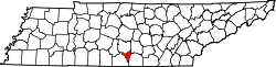 | |
| Neighborhood | ||

35°17′N 86°22′W / 35.28°N 86.36°W
| International | |
|---|---|
| National | |
| Geographic | |
| Other | |
