
Size of the above preview of this PDF file: 960 × 679 pixels. Other resolutions: 330 × 233 pixels | 960 × 679 pixels | 1,280 × 906 pixels | 3,840 × 2,717 pixels.


Original file (2,479 × 1,754 pixels, file size: 1.21 MB, MIME type: application/pdf)
Summary
| Description |
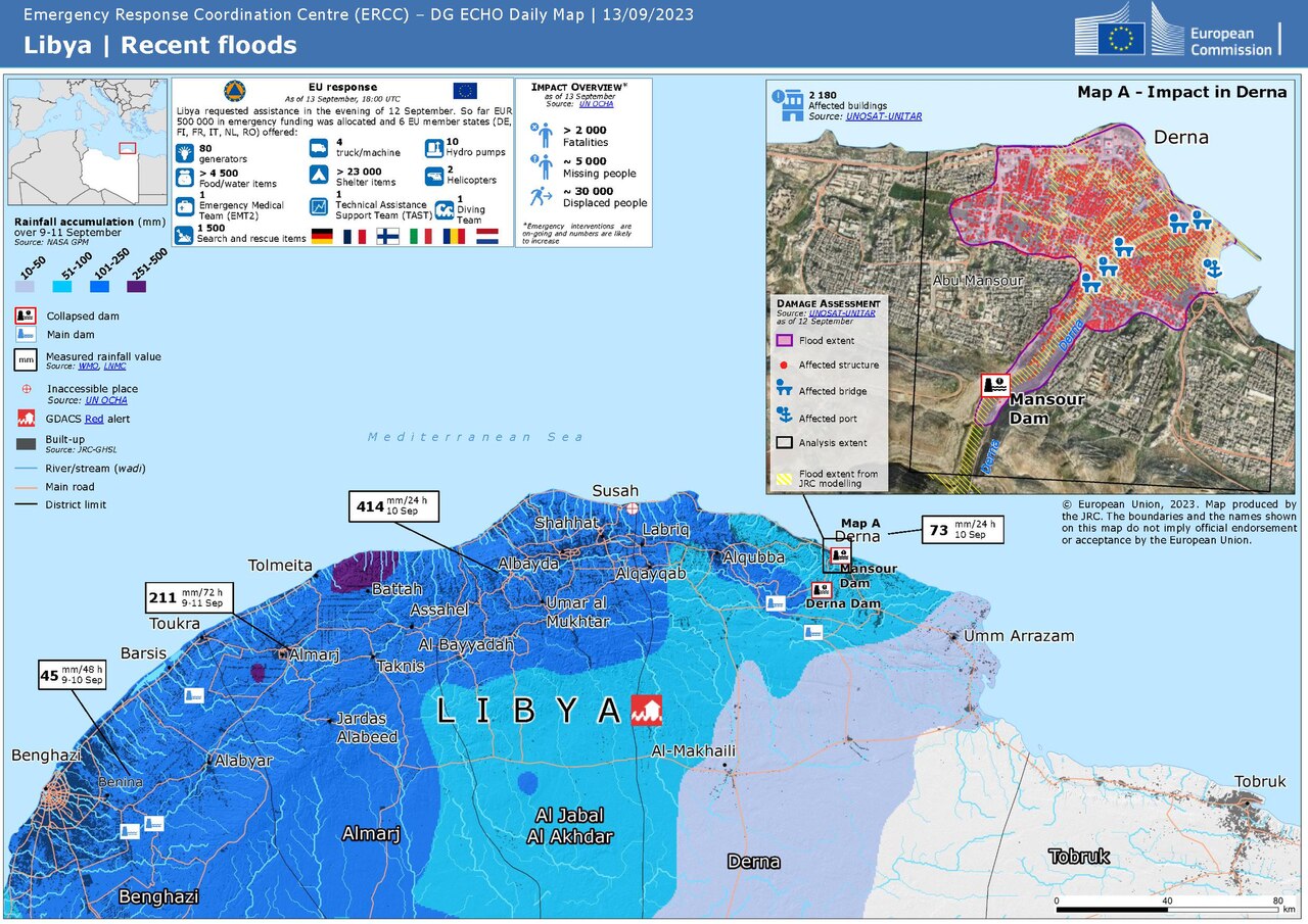
Deutsch: Überschwemmungen in Libyen im Spetember 2023 - ECHO Daily Map vom 13. September 2023
English: Floods in Libya, September 2023 - ECHO Daily Map of 13 September 2023 |
| Date | |
| Source | https://erccportal.jrc.ec.europa.eu/ECHO-Products/Maps#/maps/4636 |
| Author |
ERCC - Emergency Response Coordination Centre Sources: OCHA, NASA GPM, WMO, LNMC, GDACS, UNOSAT |
Licensing

|
Public documents (any content whatever its medium) produced by the Commission or by entities on its behalf published by the Commission or the Publications Office or which have not been published for economic or other practical reasons, such as studies, reports and other data shall be made available for reuse unless otherwise specified[1] without restrictions according to 2011/833/EU: Commission Decision of 12 December 2011 on the reuse of Commission documents
Note: Content on ec.europa.eu or its data portal is published with the specified restrictions of the CC BY 4.0 license.
|
File history
Click on a date/time to view the file as it appeared at that time.
| Date/Time | Thumbnail | Dimensions | User | Comment | |
|---|---|---|---|---|---|
| current | 14:04, 14 April 2024 |  | 2,479 × 1,754 (1.21 MB) | Don-vip | fixed number of EU states in legend (6, not 5) |
| 20:47, 13 September 2023 |  | 2,479 × 1,754 (1.21 MB) | Lupe | Uploaded a work by ERCC - Emergency Response Coordination Centre Sources: OCHA, NASA GPM, WMO, LNMC, GDACS, UNOSAT from https://erccportal.jrc.ec.europa.eu/ECHO-Products/Maps#/maps/4636 with UploadWizard |
File usage
The following 2 pages use this file:
Global file usage
The following other wikis use this file:
- Usage on ar.wikipedia.org
- Usage on be.wikipedia.org
- Usage on bn.wikipedia.org
- Usage on ca.wikipedia.org
- Usage on de.wikipedia.org
- Usage on fr.wikipedia.org
- Usage on ga.wikipedia.org
- Usage on it.wikipedia.org
- Usage on ko.wikipedia.org
- Usage on sl.wikipedia.org